Releases: microsoft/PlanetaryComputer
January 2023
Changelog
This is the changelog for the Planetary Computer January 2023 release. See previous changelogs for notes about previous releases.
This release brings a new datasets and features, including:
- Vector rendering
- New datasets
- Dataset updates
- Updates to our Terms of Use
- Notices for upcoming release
Vector Rendering
The Planetary Computer Data Catalog contains assets in a variety of common
geospatial formats, but until now the Explorer has only supported visualizing
raster data. With this release, we're introducing support for vector rendering
for collections with GeoParquet data assets. We're showcasing this feature with
the MS Buildings
dataset, which contains over 1 billion building footprints across the world.
For this, and future, GeoParquet vector datasets you'll find a new
collection-level asset
with a role of tilejson that contains a TileJSON endpoint that can be used to render the data as Mapbox Vector Tiles.
Use the Explorer
to quickly visualize the geographic coverage of the dataset:

Or overlay it with other layers to see how it fits into the broader context of the world. For example, to see villages in southern Nigeria that have very low nighttime light intensity:

New datasets
This release includes several new datasets:
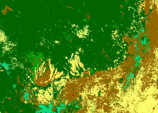
ESA Climate Change Initiative Land Cover
The ESA Climate Change Initiative Land Cover datasets consistent global annual land cover maps at 300m spatial resolution from 1992 to 2020. There are collections containing Cloud Optimized GeoTIFFs and NetCDF files.
This is a timelapse from 1992-2020 over the Amazon Rainforest in Brazil and Bolivia:
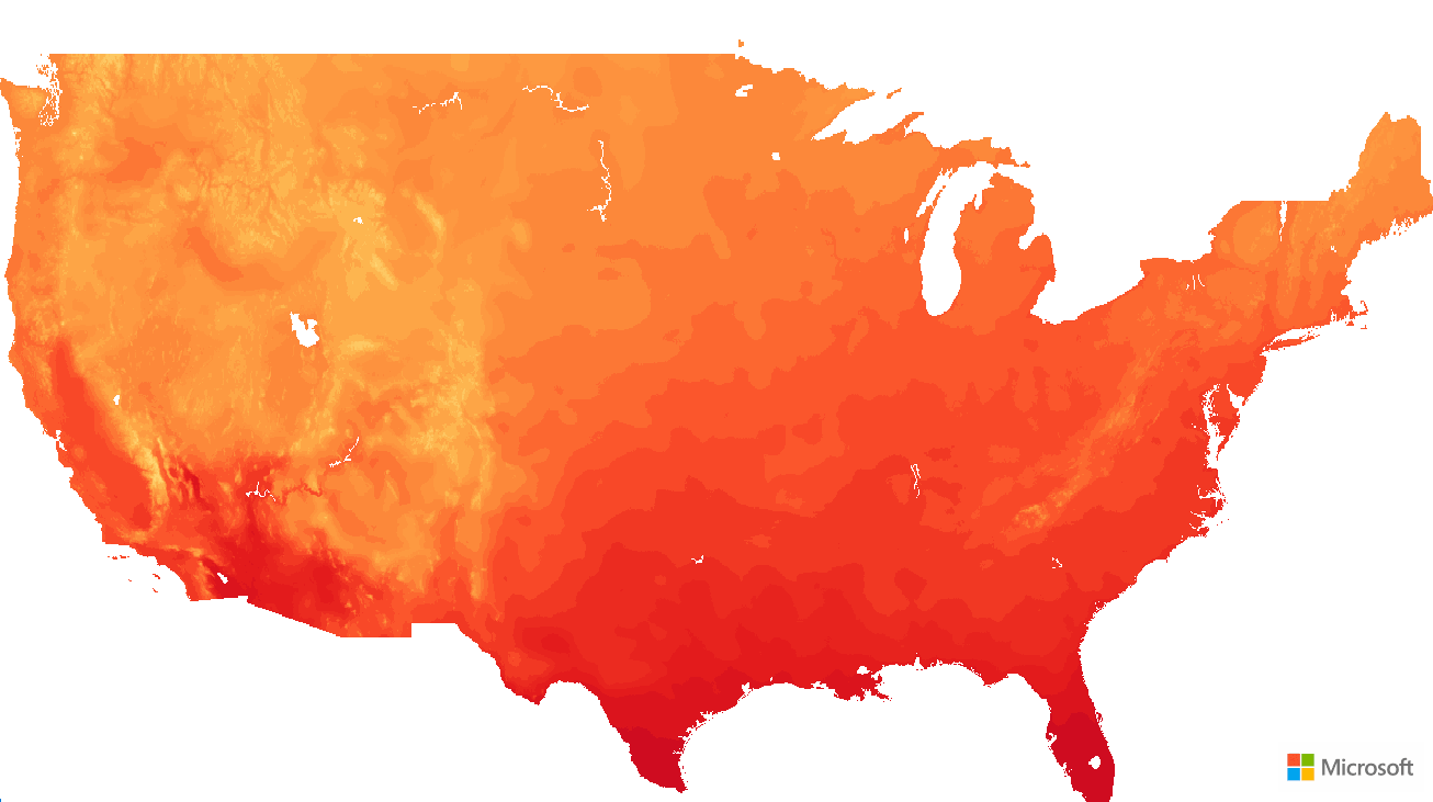
NOAA Climate Normals
The NOAA US Climate Normals datasets provide information about typical climate conditions for thousands of weather station locations across the United States.
The individual weather station data is contained in the noaa-climate-normals-tabular colleciton, which contains tabular data in GeoParquet format.
Additionally, there is gridded data provided in the collections noaa-climate-normals-gridded, which contains Cloud Optimized GeoTIFFs, and noaa-climate-normals-netcdf which contains NetCDF files.
Note that this dataset resides in the East US Azure region.

Cropland Data Layer
The USDA Cropland Data Layer is a crop-specific land cover classification product of more than 100 crop categories grown in the United States.

USGS Land Change Monitoring, Assessment, and Projection
The USGS Land Change Monitoring, Assessment, and Projection (LCMAP) datasets provide land cover mapping and change monitoring from the U.S.
There are two datasets; one containing "Collection 1.3" data for the Conterminous United States (usgs-lcmap-conus-v13) and another containing "Collection 1.0" data for Hawaii (usgs-lcmap-hawaii-v10)
This is a timelapse from 1985-2021 over California's Plumas National Forest:

National Wetlands Inventory
The FWS National Wetlands Inventory collection contains more than 35 million wetland and deepwater features. This dataset covers the conterminous United States, Hawaii, Puerto Rico, the Virgin Islands, Guam, the major Northern Mariana Islands and Alaska.

Dataset updates
NOAA GOES updates
- GOES-18 data is now available in the Cloud Moisture Index (goes-cmi) collection.
- Additional data products for GOES that are not yet in the API are documented in the catalog: Fire Detection and Characterization (FDC), Land Surface Temperature (LST), Rainfall Rate and Quantitative Precipitation Estimation (RRQPE), and Sea Surface Temperature (SST)
- The goes-cmi collection now has a render configuration that utilizes infrared data to better visualize night-time scenes. See this example in the Explorer.
Other dataset updates
- TerraClimate was updated to include the latest data from the producer, the Climatology Lab. The dataset now covers 1958 - 2021. Note that some variables, such as the station influence variables, are no longer provided. The Zarr store linked from the STAC collection is at a new URL. The data at the old URL will be deleted sometime in the future. In addition, the STAC metadata now includes the latest updates from the
xarray-assetsSTAC extension. - The NOAA National Water Model data products, which are hosted but not yet fully integrated into the API, are now documented in the data catalog.
- Using new functionality in stactools, the footprints in the ASTER collection have been update to better match the actual image data, rather than the full raster extent.
- Collections now have an
msft:regionproperty, which indicates the Azure Region in which the data is hosted. - The Microsoft Building Footprints dataset can now be visualized in the Explorer, using the vector rendering feature described above.
Documentation Improvements
- Added a new Sentinel-2 notebook demonstrating the Sentinel-2 L2A Baseline Change, and how to harmonize data across it.
- Expanded the Data Catalog documentation to include a new section on how the Planetary Computer relates to data providers like the NOAA Open Data Dissemination program.
Updates to our Terms of Use
Our Terms of Use has been updated to clarify terms about the data access tokens issued by the Planetary Computer for data access. No change in behavior or permissions has occurred. Please read the Terms of Use to get more infor...
October 2022
We're pleased to announce our June 2022 release! This release includes improvements to the data catalog and Explorer user interface, support for bulk queries with GeoParquet, and several new datasets. Feel free to post comments and questions in the thread below.
This release brings a number of new features to the Explorer app, including:
- Item preview mode
- Generate a timelapse GIF for a dataset mosaic
- Generate a static image of a dataset mosaic
- Advanced filter allows settings time in ranges
- Ability to change sort order of search results
This release also includes several new datasets:
New datasets
This release includes several new datasets:
GOES-R Lightning Detection
GOES-R Lightning Detection:
Continuous lightning detection over the Western Hemisphere from the Geostationary Lightning Mapper (GLM) instrument.

NOAA MRMS QPE
- NOAA MRMS QPE 1-Hour Pass 1: Integrated multi-sensor cumulative precipitation estimate for the past hour with a 1-hour latency.
- NOAA MRMS QPE 1-Hour Pass 2: Integrated multi-sensor cumulative precipitation estimate for the past hour with a 2-hour latency.
- NOAA MRMS QPE 24-Hour Pass 2: Integrated multi-sensor cumulative precipitation estimate for the past 24 hours with a 2-hour latency.

NOAA Monthly NClimGrid
NOAA Monthly NClimGrid: Monthly Climate Gridded dataset with data on temperature and precipitation.
Denver Regional Council of Governments Land Use Land Cover
Denver Regional Council of Governments Land Use Land Cover: 1-ft resolution land use / land cover dataset around Denver, Colorado.

Chesapeake Land Cover/Land Use
Chesapeake Land Cover (7-class): 1-meter land cover data product for the entire Chesapeake Bay watershed with a uniform set of 7 land cover classes.

Chesapeake Land Cover (13-class): 1-meter land cover data product for the entire Chesapeake Bay watershed with 13 varying land cover classes.

Chesapeake Land Use: 1-meter land use data product for the entire Chesapeake Bay watershed.

June 2022
We're pleased to announce our June 2022 release! This release includes improvements to the data catalog and Explorer user interface, support for bulk queries with GeoParquet, and several new datasets. Feel free to post comments and questions in the thread below.
Highlights
- The Catalog and Explorer interfaces have been redesigned to accommodate the increased number of datasets available in the Planetary Computer.
- The entire website, including the Explorer, Catalog, and Documentation pages, have all been updated to work well on most mobile devices.
- We now provide snapshots of our STAC items for most of our collections as GeoParquet datasets to support bulk STAC queries.
Bulk STAC queries with GeoParquet
Many of our collections now include a geoparquet-items collection-level asset that links to a GeoParquet dataset in Azure Blob Storage. Each row in these Parquet datasets is a STAC item. While most users should continue to use the normal STAC API, these Parquet datasets are a nice complement for workloads that need to return very many STAC items.
See Bulk STAC item queries with GeoParquet for more. Discuss this on the GeoParquet board.
New datasets
This release includes several new datasets in our STAC API. Each of these links to the dataset details page, which includes an example notebook.
- Deltares Floods
- Deltares Water Availability
- Microsoft Building Footprints
- Kwando & Upper Zambezi Rivers HydroForecast
Discuss this in the release thread.
May 2022
We're pleased to announce our May 2022 release! This release includes several performance improvements, API enhancements, and many new datasets.
Highlights
- Improved performance and scalability of our STAC API. Requests to our STAC API, including searches, will return faster and scale to larger concurrent loads. See the pgstac 0.5 and 0.6 release notes for more.
- The Explorer now includes the ability to pin layers, allowing you to compare multiple queries. See working with multiple layers for more.
- Many new datasets are available through our catalog. See the datasets section below for more.
New datasets
This release includes many new datasets. Each of these links to the dataset details page, which includes an example notebook.
- Sentinel-1: Synthetic Aperture Radar raster products, including the world's first openly licensed (CC-BY-4.0), globally available radiometrically terrain corrected Sentinel 1 product.
- Sentinel-1 RTC: Global radiometrically terrain corrected SAR imagery derived from the Sentinel 1 Level 1 GRD product.
- Sentinel-1 GRD: Focused SAR data that has been detected, multi-looked and projected to ground range using an Earth ellipsoid model.
- Landsat: Imagery from Landsat 1-9, starting from 1972.
- Landsat Collection 2 Level-1: Landsat Collection 2 Level-1 data from the Multispectral Scanner System (MSS) onboard Landsat 1 through Landsat 5.
- Landsat Collection 2 Level-2: Landsat Collection 2 Level-2 data from the Thematic Mapper (TM) onboard Landsat 4 and 5, the Enhanced Thematic Mapper Plus (ETM+) onboard Landsat 7, and the Operational Land Imager (OLI) and Thermal Infrared Sensor (TIRS) onboard Landsat 8 and 9.
- MODIS imagery and derived products, starting from 2000.
- MODIS Burned Area Monthly: MODIS Burned Area Monthly
- MODIS Gross Primary Productivity 8-Day Gap-Filled: MODIS Gross Primary Productivity 8-Day Gap-Filled
- MODIS Gross Primary Productivity 8-Day: MODIS Gross Primary Productivity 8-Day
- MODIS Land Surface Temperature/3-Band Emissivity 8-Day: MODIS Land Surface Temperature/3-Band Emissivity 8-Day
- MODIS Land Surface Temperature/Emissivity 8-Day: MODIS Land Surface Temperature/Emissivity 8-Day
- MODIS Land Surface Temperature/Emissivity Daily: MODIS Land Surface Temperature/Emissivity Daily
- MODIS Leaf Area Index/FPAR 4-Day: MODIS Leaf Area Index/FPAR 4-Day
- MODIS Leaf Area Index/FPAR 8-Day: MODIS Leaf Area Index/FPAR 8-Day
- MODIS Nadir BRDF-Adjusted Reflectance (NBAR) Daily: MODIS Nadir BRDF-Adjusted Reflectance (NBAR) Daily
- MODIS Net Evapotranspiration Yearly Gap-Filled: MODIS Net Evapotranspiration Yearly Gap-Filled
- MODIS Net Primary Production Yearly Gap-Filled: MODIS Net Primary Production Yearly Gap-Filled
- MODIS Snow Cover 8-day: MODIS Snow Cover 8-day
- MODIS Snow Cover Daily: MODIS Snow Cover Daily
- MODIS Surface Reflectance 8-Day (250m): MODIS Surface Reflectance 8-Day (250m)
- MODIS Surface Reflectance 8-Day (500m): MODIS Surface Reflectance 8-Day (500m)
- MODIS Thermal Anomalies/Fire 8-Day: MODIS Thermal Anomalies/Fire 8-Day
- MODIS Thermal Anomalies/Fire Daily: MODIS Thermal Anomalies/Fire Daily
- MODIS Vegetation Indices 16-Day (250m): MODIS Vegetation Indices 16-Day (250m)
- MODIS Vegetation Indices 16-Day (500m): MODIS Vegetation Indices 16-Day (500m)
- USGS 3DEP: Lidar elevation data as Cloud Optimized Point Cloud (COPC) and derived Cloud Optimized GeoTIFF (COG) data processed from the USGS 3D Elevation Program.
- USGS 3DEP Lidar Point Cloud
- USGS 3DEP Lidar Height Above Ground (HAG)
- USGS 3DEP Lidar Classification
- USGS 3DEP Lidar Digital Surfice Model (DSM)
- USGS 3DEP Digital Terrain Model (DTM)
- USGS 3DEP Digital Terrain Model (Native)
- USGS 3DEP Lidar Point Source
- USGS 3DEP Lidar Intensity
- USGS 3DEP Lidar Returns
- NAIP: National Agriculture Imagery Program (NAIP) imagery updated for 2020
- CIL Global Downscaled Projections for Climate Impacts Research Collection: Climate Impact Lab Global Downscaled Projections for Climate Impacts Research
- ECMWF Open Data (real-time): ECMWF Open Data (Real Time) forecasts
- ERA5 - PDS: A comprehensive reanalysis, which assimilates as many observations as possible in the upper air and near surface.
- ESA WorldCover 2020: Global land cover product at 10 meter resolution for 2020 based on Sentinel-1 and Sentinel-2 data
- ALOS Forest/Non-Forest Annual Mosaic: Global 25-meter resolution map classifying "forest" and "non-forest" landcover.
- ALOS PALSAR Annual Mosaic: Global 25-meter resolution SAR image mosaic.
- NOAA C-CAP Regional Land Cover and Change: Periodic coastal landcover classifications back to 1975
- Urban Innovation Eclipse Sensor Data: A network of low-cost air quality sensing network for cities and led by the Urban Innovation Group at Microsoft Research
- Planet NICFI:
- Planet-NICFI Basemaps (Analytic): Planet's high-resolution, analysis-ready mosaics of the world's tropics (Microsoft - GEO RFP winners only)
- Planet-NICFI Basemaps (Visual): Planet's high-resolution, analysis-ready mosaics of the world's tropics (Microsoft - GEO RFP winners only)
API updates
STAC API
- Updated the STAC API to v1.0.0-rc.1
- Initial support for queryables in the STAC API. See Sentinel-2-l2a for an example. Additional queryables and more metadata description in coming releases.
- Scalability and performance improvements.
Data API
- Upgrades to pgstac-titiler 0.1.0a7
- Scalability and performance improvements.
Documentation and Tutorials
In addition to the dataset examples, we have several new tutorials going in-depth on a specific topic.
- Customizable radiometric terrain correction of Sentinel-1 products using the open-source sarsen package.
- Computing climate indicators with xclim
#...